Come & Explore
the Narrabri Region.


With a mix of country charm and soul, Narrabri Region is captivating, and inviting. Explore the Narrabri Region in the heart of the rich Namoi Valley in North West NSW, where you will find our way of life relaxed and genuinely warm.

Explore
Our Attractions
Sculptures in the Scrub

Featured
Must see!
Narrabri Fish Farm

Featured
Must see!
Yarrie Lake

Featured
Must see!
Namoi Echo Museum

Featured
Must see!
Old Gaol Heritage Museum

Featured
Must see!
Boggabri Tractor Shed

Featured
Must see!
Sawn Rocks

Featured
Must see!
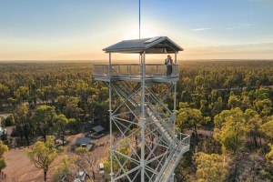
Salt Caves and Forest Lookout Tower

Featured
Must see!
Pilliga Artesian Bore Bath

Featured
Must see!
Pilliga Forest

Featured
Must see!

Bookings
Pilliga Hot Artesian Bore Baths Campground Booking

Getting to Narrabri Region
Transport links and information to help you reach your destination and explore our region.

Itineraries & Tours
See our suggested itineraries for ways to spend your day in the Narrabri Region.


Released every Friday by the Narrabri Region Visitor Information Centre, What’s On Weekly will keep you informed about everything happening within the Narrabri Region over the upcoming weekend.